Tools, Techniques, and Methods
Changes in technologies greatly influenced the mapmakers’ art. The introduction of the compass, telescope, sextant, quadrant, theodolite, vernier scale, clock, and triangulation permitted more precise and reliable maps. With the printing press, they gained the ability to make accurate reproductions. Cartographers compiled information from all kinds of sources: memories; surveys or field work with auxiliary instruments; and mathematical, geometric, and astronomical calculations; sketches, and other maps.
![The civil engineers's pocket-book, of mensuration, trigonometry, surveying, hydraulics ... [etc.]: in addition to which the elucidation of certain important principles of construction is made in a more simple manner than heretofore](https://api.library.tamu.edu/iiif/2/3334701d-2e17-381c-adb7-6dcf12e1ee9a/full/!400,400/0/default.jpg)
Maps position specific geographical locations in relationship to an imaginary grid system, the lines of longitude and latitude. The imaginary lines are further broken down into minutes and seconds. When a surveyor or mapmaker transfers these points and their surrounding features to paper, a map is begun. A control point, typically a notable or well-known feature, is established by surveyors using devices to record horizontal distances and vertical elevations. The survey data generated are then used to prepare the maps.
The surveying process creates a control point and series of supplemental points to describe land. A very traditional method was "Metes and Bounds." Metes use a known landmark for starting point and then follows a line according to the compass-needle (or magnetic bearing). Bounds are a more general boundary description referring to existing natural features or human constructions. Rods and chains, typically used in English colonies, or pre-measured ropes, in Spanish colonies, were used to measure distance. As landmarks decay and change, and a compass-needle does not always point due North, using these devices resulted in endless confusion and lawsuits.
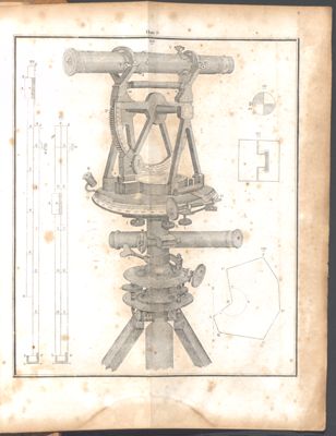
Introduced in 1615, triangulation, a marked improvement for land measure, made cartography much more reliable. Tools like a Jacob’s staff were used to determine the height and angle of objects relative to the person using the staff. More precise still was a theodolite, which allows for large-scale triangulation and mapping, as was needed for the 1857 United States and Mexican Boundary Survey.