Search Results
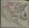
41. Map of the United States
42.
Hispania nova

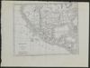
43.
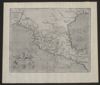
Mexico and Guatemala

44.
[Plan del presidio de San Sabá al de los Adaes y San Antonio de Véxar, comenzando desde el Nuevo Reino de Orleans demarcando todos los presidios, misiones, fuentes, pueblos y demás casas, de que se compone el ámbito de dicho mapa.]

45.
An account of expeditions to the sources of the Mississippi and through the western parts of Louisiana, to the sources of the Arkansaw, Kans, La Platte, and Pierre Jaun, rivers: performed by order of the government of the United States during the years 1805, 1806, and 1807...
46.
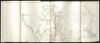
Topographical Map of the Road From Fort Smith, Arks. to Santa Fe, N.M. and from Donna Ana N.M. to Fort Smith: made by the order of Bvt. Grig Gen. M. Arbuckles, U.S.A. by Capt. R.B. Macy, 5th U.S. Inf.

47.
A new map of Mexico and adjacent provinces
48.
The civil engineers's pocket-book, of mensuration, trigonometry, surveying, hydraulics ... [etc.]: in addition to which the elucidation of certain important principles of construction is made in a more simple manner than heretofore
49.
Instructions for range surveys as formulated by the Inter-Agency Range Survey Committee and adopted by the Western Range Survey Conference, April 24, 1937
50.
Messico e Guatimala
51.
Holdings: Reports of the Secretary of War: with reconnaissance of routes from San Antonio to El Paso.
52.
A treatise of practical surveying

53.
Report on the United States and Mexican boundary survey ; made under the direction of the secretary of the Interior

54.
Libro mui curioso en que seda noticia, y se explica claramente el modo de observar y lo que deve hacer el Medidor antes de la vista de Ojos y su medida El qual Libro sirve para el uso, y recreo honesto de el S.or Dn. Joseph Antonio Tarelo. Por la gracia de Dios. Labrador-climaterico, y mui inteligente en todas Facultades
55.
A treatise on surveying: containing the theory and practice, to which is prefixed a perspicuous system of plane trigonometry : the whole clearly demonstrated and illustrated by a large number of appropriate examples, particularly adapted to the use of schools

56.
Portulano de la America Setentrional: dividido en quatro partes
57.
Manuscript journal of maps: Surveying Texas and New Mexico, by E.A. Baue

- « Previous
- Next »
- 1
- 2
- 3