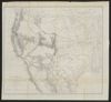
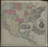
Nouvelle Carte du Mexique, Du Texas Et D'Une Partie Des Etats Limitrophes; Dediee a l'Academie Royale des Sciences de l Institut de France. Par A.H. Brue, Geographe du Roi, Membre de la common. centrale de la societe de Geographie de Paris, membre-honoraire de celle de Londres, and a. Revue et augmentee par Ch. Picquet, Geographe du Roi et du Due d'Orleans, Proprietaire des Cartes et Atlas de Brue, Quai Conti No. 17, pres de l'Institut. Paris, 1840. Publiee en 1834; Revue en 1837, 1839, 1840
A.R. Roessler's latest map of the state of Texas : exhibiting mineral and agricultural districts, post offices and mailroutes [sic], railroads projected and finished, timber, prairie, swamp lands, etc. etc. etc.
Texas: eine geographische Skizze bearbeitet nach Berghaus Länderkunde und den neuesten Forschungen des Prinzen Carl zu Solms Braunfels und anderer Reisenden
Appletons' southern and western travellers' guide : with new and authentic maps, illustrating those divisions of the country, and containing sectional maps of the Mississippi and Ohio rivers, with plans of cities, views,etc...
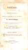
Texas: observations, historical, geographical and descriptive : in a series of letters, written during a visit to Austin's colony, with a view to a permanent settlement in that country, in the Autumn of 1831
Annexation of Texas to the United States: Message from the President of the United States, in compliance with a resolution of the House of Representatives of the 13th instant, respecting an annexation of Texas to the United States.
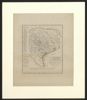
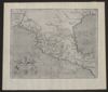
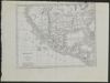
Regni Mexicani seu Novae Hispaniae, Ludovicianae, N. Angliae, Carolinae, Virginiae et Pensylvaniae necnon insularum archipelagi Mexicani in America Septentrionali
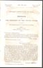
Texas: Message from the President of the United States transmitting the rejected treaty for the annexation of the Republic of Texas to the United States, together with the accompanying documents
[Plan del presidio de San Sabá al de los Adaes y San Antonio de Véxar, comenzando desde el Nuevo Reino de Orleans demarcando todos los presidios, misiones, fuentes, pueblos y demás casas, de que se compone el ámbito de dicho mapa.]
An account of expeditions to the sources of the Mississippi and through the western parts of Louisiana, to the sources of the Arkansaw, Kans, La Platte, and Pierre Jaun, rivers: performed by order of the government of the United States during the years 1805, 1806, and 1807...
Topographical Map of the Road From Fort Smith, Arks. to Santa Fe, N.M. and from Donna Ana N.M. to Fort Smith: made by the order of Bvt. Grig Gen. M. Arbuckles, U.S.A. by Capt. R.B. Macy, 5th U.S. Inf.
The civil engineers's pocket-book, of mensuration, trigonometry, surveying, hydraulics ... [etc.]: in addition to which the elucidation of certain important principles of construction is made in a more simple manner than heretofore
Instructions for range surveys as formulated by the Inter-Agency Range Survey Committee and adopted by the Western Range Survey Conference, April 24, 1937